Category Archives: Hikes

Betty, you can call me Owl’s Head (48/48)

“It always reminds me of my mom cleaning the house.”

“That’s funny. It reminds me of going to Rutgers Women’s Basketball games when I was a kid.”

Jeremy and I shared our visceral, sensory memories cruising along to the classic Paul Simon hit, “You Can Call Me Al”, on our way north on Rt. 93 in New Hampshire. Jeremy recalls how his mother would play Simon’s songs while vacuuming and dusting, spreading the fresh scent of lemon and pine sol throughout his campground childhood. For me, the song’s refrain brings me back to the stands of the Rutgers Athletic Center with my mother, listening to the pep band and shaking a red pom-pom while the Women’s Basketball team ran around the court.  The song is not a favorite, and if I’m being honest, I’m not even a fan of Paul Simon. I’m told time and time again how great he is, mostly by my father. Still, while I may skip over Me & Julio or Mrs. Robinson, I pretty much always give Call Me Al a listen through, and will tend to bob along to the horns.

Jeremy is an old friend. We met many years ago in a bar in Philadelphia, both as members of the same runnings club– The Raritan Valley Road Runners. I was just joining the club, as a new-to-running, excited half-marathoner while Jeremy was on his way out of the club, and out of the New Jersey area. Still, in the age of Facebook, we stayed connected and managed to meet again in a familiar culture in Boston, MA– at a bar after a run with a new running club. Soon, we were exploring festivals in the city, biking, and sharing beers and family style dinners together and with other club members. Where Jeremy had added the most value to my life, however, is on the trails.

IMG_2306.JPG

Finding company to conquer the mountain trails with might come easy to some people. Others might prefer total solitude, knowing that sharing the experience would detract from it. Personally, I am stuck in the middle of wanting to share the experience and wanting to keep it selfishly for myself. Finding a trail partner who can bridge those experiences and allow for both in a single day might be the biggest treasure I’ve discovered since starting my journey to summit all 48 4000 footers in New Hampshire. It is merely a gigantic bonus that Jeremy happens to also be beloved by my dog, Sky Girl. There is no human she’d rather see than Jeremy and I daresay she might choose him over some tasty bacon if presented the dilemma of choice.

Driving north on Rt. 93 out of Massachusetts and into New Hampshire really can only mean one thing this time of year– foliage. I’m sure that Autumn is beautiful across many regions in these United States, but I’m damned positive that nothing is quite like New England. As my students would say, Fall is “lit”. As we throttle 80 mph north, looking out and see 5 different shades of orange across a single tree. While cruising north, Jeremy and I were certainly on the hunt for foliage, but we were also on a mission to climb a mountain.

IMG_2322

Get these mutts away from me
You know I don’t find this stuff amusing anymore

One way in, one way out. Our plan was simple, straightforward, and predictable. We were heading out to climb Owl’s Head mountain, my final peak in the list of 4000 foot mountains in New Hampshire. We would take the ‘standard route’, via Lincoln Woods, Franconia Brook, Lincoln Brook, Owl’s Head Path, and the herd path bushwhack to the true summit. There, we would celebrate with a beer and a high five before about-facing and heading on out the same way we had come. This hike offered 18+ miles RT of some of the most remote parts of the White Mountains, nestled deep in the heart of the Pemigewasset Wilderness.

Owl’s Head is no Goliath. It sits at a cool 4,025 ft. high, offers no views from the summit nor even a maintained path to the summit. It sits just under it’s flanking ranges– the Twin Range and Franconia Range– almost hiding from their prowess. Owl’s Head is special for it’s quiet, humble seat– situated after 9 miles of hiking, no expansive vistas, no swag or thrills for the peak bagger. And for a mountains of such small stature, it sure is a difficult one. She is truly more David.

IMG_2284.JPG

A man walks down the street
It’s a street in a strange world

I’ve hiked along sections of the Pemi Loop many times and always stared down into the Colosseum created by the Bonds and Franconia Ridge, which would lie vastly empty without Owl’s Head shooting up out of nothing. Like Mt. Isolation, the mountains is so much lower than it’s towering neighbors that a hiker standing on the summit of Mt. Lafayette would have to bow his or her head in respect to see the crest of Owl’s Head. This mountain eluded me, and I intended on changing that.

IMG_2291.JPG

He is surrounded by the sound

Singletrack, take me back. Hitting # 48 was just so. After climbing the rock slide and following the foot path, it started to snow. Medium sized, wet flurries were gently falling. The snow made the summit seem even quieter, although perhaps that was just the constant wind drowning out noise. Jeremy and I each cracked open a beer, a DIPA from Lone Pine Brewery called “Tess” (can you tell why I like it?). As people came and reached the summit with us, we shared memories of other hikes, knowledges of other trails, and even another person hitting her 48th. What a remote place to have so much foot traffic.

Perhaps my favorite part of the hike was leaving the summit. I don’t really know how, but a single beer made me quite tipsy. With both the list of the 48 peaks and my inhibitions behind me, I descended the slide in leaps and bounds. My ass hit the rocks once or twice, but they were met with laughter and smiles. We met 2 other descenders on the slide, one of whom shared some of his 100 miler experiences with us. We had passed these gentlemen earlier, but they had abandoned their friend, Frank, who turned for Lincoln Woods when the water crossings got the better of him. At the bottom of the slide, we recovered ourselves and then started to run. With unspoken intentions, Sky, Jeremy, and I raced out of there, running quite bravely over some technical terrain. We were on a mission– find Frank!

Later, when we finally caught up with the elusive hiker, we both gave him an exalted “Are you Frank?? Your friends are coming!” as though we were messengers in a great important battle. Frank turned and looked mildly surprised and muttered something along the lines of “okay, great.” Clearly, he didn’t realize how important this was.

IMG_2311.JPG

If you’ll be my bodyguard, I can be your long lost pal.

I’m finally done. I’ve hiked all 48 of the 4000 footers, joining the ranks of probably thousands of others, and hundreds more who aren’t officially keeping track. This goal was more important to me 4 year ago when I started, and I started this blog in honor of it. I guess this means I can stop hiking, right? Nah, I’ll get Sky Girl her final 2 peaks (Waumbek & West Bond) and then maybe seek some new territory. Perhaps Paul Simon did put it best, I “don’t want to end up a cartoon in a cartoon graveyard.”


Crabby Cabot and Kill me Killington (47/48; 5/5) & The End of Alternative Summer 2018

Can you believe I’ve only made it up to the mountains 4 times this summer? I understand that 4 times may seem like a lot to the naked eye, but I assure you that it feels like a prolonged absence from the place I love each summer. I made it up to Garfield and Franconia Ridge with Victor back in June. It was hard to “hike” everything, knowing that running itself is not the danger, but falling was a big risk. To refresh your memory, I am recovering from Pulmonary Embolism diagnosis back in May, and am on a course of Xarelto for 6 months. Running is an approved and encouraged activity… but physical trauma is actually quite dangerous with a risk of internal or external bleeding. This doesn’t mean I haven’t been a little risky… but never in some place as remote as the summit of a mountain or alone.

I’ve been calling this summer the “Try New Things” tour or my “Alternative Summer”. I haven’t been training for any long ultra-marathons, and I haven’t been spending all my free time in the mountains. This has given me the freedom to explore new activities and new places right in my home city of Boston. Instead of heading north every weekend, I’ve been able to spend time locally and finding new corners of my neighborhood to enjoy. This whole year has been about making fewer excuses to try new things, and that philosophy exploded this summer.

For example, I have spent a large amount of time on the river this summer. I bought a season kayak/canoe/SUP pass and have done all 3 of those activities. I’ve even been able to take Sky Girl out on the river with me, where we were quite a hit with everyone on bridges we paddled under. I have always loved the water, not just swimming but the calm of a river or lake. Even in the hottest days of the year, setting out on a board with the pup was never out of the question. This activity was made even more enjoyable by the masses of my friends, from different circles of my life, who also enjoyed summertime on the river.

Another river activity that deserves some written real estate in this post was the great tubing adventure on the Deerfield River. I’ve sat in a lazy tube before, with a floating cooler and an incipient summer sunburn, but this tubing adventure is what I would call “active tubing”. Jeremy invited myself, Victor, Mark, and Seero out to the Berkshires (the most magical place in MA) to go tubing down the river. If you are picturing the lazy tubing, please wipe your mental canvas clean and instead picture a rushing river with class 3 rapids, where we went 4 miles in an hour. This trip was like one long slide, where you had to dodge rocks and attempt to paddle with your nearly useless hands outside the tube, while getting splashed. Storms threatened and sunglasses were lost (sorry, Mark). I had a blast, possibly the most fun single hour activity I’ve participated in.

I could go on and on about this alternative summer. There were other activities (mountain biking, visiting new parts and parks in Boston, etc.) but by August, I was ready to get back to my familiar happy place, climbing in the mountains.

Cabot is so far north. Holy crap! Jeremy and I left on one of the last days of August with the intention to drive up to Cabot, conquer that bad boy, camp out, and then hit Owl’s Head. The day did not follow as ideally as we had hoped. First, I woke up that morning with a horrible sore throat. I have been battling a sore throat on/off since coming home from San Diego and it seems like every 3 days it returns. That morning, I woke up feeling sick and questioned my ability to hike and camp. I was thinking about what would happen if I wore my body out and then got real sick again, worse than just a sore throat. After sleeping a little more, I decided I’d at least try it. So with the late start, Jeremy and I headed north, and north… and when it doubt just keep driving north…

Cabot is WAY the hell up there! After what felt like an eternity, we made it to the fish hatchery. Neither of us has hiked Cabot before, and a quick google search claimed that the gate at the hatchery closes at 4:30pm. The trailhead is a 2 mile road walk/run away from the gate… so Jeremy and I had a decision to make. After realizing that we could take our time, we left the car on the outbound side of the gate and added 4 miles to the 11 mile loop. We hiked the Cabot loop counterclockwise, heading up Unknown Pond trail first, then hitting the Horn and the Bulge and finally summiting Cabot and then heading down.

The day we chose was HOT. Not only hot but HUMID. Like, stupid humid. Like only stupid humans would venture on a day like today. And only stupid humans would bring a dog and make a dog do this hike on a humid day like that. Well, I don’t claim to be very smart…

Speaking of Sky, she did absolutely great on this 15-mile day! She showed no signs of slowing down, no signs of fatigue, and she was actually running down the road faster than Jeremy and myself at the end. Her strength surprised me, as she isn’t the young pup that she was when I first got her (she’s not old, but just not young) and her road running is very slow these days. This pleasant surprise is encouraging me to bring her on more, longer mountain days.

Anyway, Jeremy and I camped on the Kanc after this and decided to lick our wounds and go home the next day, saving Owl’s Head for another day.

Vermont High Peaks—CHECK. Over the Labor Day Weekend, Victor and I made last minute plans to head up and check out some trails. We didn’t want to stay in the Whites, and I assumed that we would be unable to since they apparently get more visitors than Yosemite per year (Jeremy’s claim!) so instead we thought about doing some trails in Vermont. That made me remember that I only had 1 more of the Vermont 4000 footers to summit, Killington, to finish the list.

Victor planned a cool 20 mile loop starting and ending at our campsite in Gifford Woods State Park. GW is a great place to camp if you are looking for a place in that area. There are plenty of amenities, it’s very clean and well maintained, and you have access to many trails from right there—including the AT and the LT.

Our loop changed slightly, based on quality of the trail, but we ended up making a large loop and out-and-back out of the Long Trail and the AT. We ended up heading up Pico, over and back to Killington, and then back down. We ran into Hannah Hawley just driving by on the road during one of 2 road crossings, which is kind of amazing. The total mileage was 19 miles and almost 5,000 ft of gain.

As fall approaches, I am looking forward to finishing my NH 48 during peak foliage. Owl’s Head is probably the most remote mountain of the list, nestled so snuggly within the heart of the Pemi Wilderness. It’s a 16-18ish mile out and back hike from Lincoln Woods (although of course you can make more mileage out of it from other locations) and I’m looking forward to using it as a big training day.

I started this blog with this list in mind, but it’s turned into a wilder journey than I could’ve predicted. I slowed down my progress so much that for a while I was wondering if I’d ever finish the list at all. I’m not done yet, so I will just keep wondering.

A Taste of Freedom: North Carolina Spring Break Road Trip

I heard tell of North Carolina being a pretty cool state but it was hard for me to really believe those rumors. That southern heat? No gnarly rocks? No snow? How cool could that place be?

…pretty friggin’ cool apparently.

Out of need to explore the world a little bit beyond the Northeast, I decided to drive down to Asheville, NC for my spring break. School friend and NC native, Kayla, was awesome enough to join me for the journey. We would shoot down to the western part of the state for a few days and then mosey on over to Raleigh/Durham area to see her family before making the long drive home.

Highlights include driving down in the BOMB, seeing Sarah in the wild, & seeing Sarah in the city.

Nothing like a large and scary wind/rain/snow/sleet storm to start spring break off! We hit the road before 10am on Friday and were windswept in traffic for a long day. There were downed trees across Connecticut, rain puddles flooding roads in New Jersey, and white out snow across highways in Pennsylvania. A+ driving weather for a champion behind the wheel, like me (sarcasm turned up to 10 there). After making our way through MA, CT, NY, NJ, PA, MD, WV, VA, TN, and part of NC during 2 days (one night in a Travelodge), Kayla, Sky girl and I arrive safely in Asheville.

We spent our time split pretty well between the mountains/trails and eating/drinking our way through downtown. We also dedicated one full afternoon to seeing the Biltmore estate. On our way out of western NC, we headed north to hike Grandfather Mountain, a mountain Kayla swears she hiked as a child but her parents deny that claim. Either way, now she’s hiked it. Then we headed through the foggiest goddamn valley I’ve ever encountered, stopped at a delightful establishment called Cook Out, and arrived by evening in Raleigh.

After a few days in the triangle portion of the state, bummin’ around the Tobacco District and checking out a few more breweries and meeting some family members and eating some enchiladas, we CRUSHED the 1 day drive home on a Friday with the potential for traffic. We listened to many podcasts, some at the recommendation of friends and family (Thanks Ashley for the strange tale of zombie killing and Dirty John, and thanks Sean for throwing us into the fantasy fiction of Monster of the Week DnD style character arcs of The Adventure Zone.)

This trip was pretty freeing. I think I will have a hard time refocusing my day-to-day back to work, not that I was heavily focused before the trip or anything.

Mountains/Trails

We went for 3 hikes in the Asheville portion of the trip and I went on 1 hike in Raleigh. 2 were a little more strenuous than the others, which were really more of a ‘dog tiring’ walk.

First, we hiked up Mt. Mitchell via the Old Mt. Mitchell trails. It’s ~12 miles round trip with over 3500 ft elevation gain. Mt. Mitchell (6683 ft) is the tallest mountain on the east coast, topping out a bit higher than my beloved Mt. Washington (6288 ft).

Mt. Mitchell is located in the Black Mountain range. It sits among other pretty tall mountains, several above 5000ft. It’s weather is nothing near as volatile or uninviting as the northeast, unsurprisingly. In fact, on the day we hiked it was warm with no wind at the summit. Many people who had driven up were in shorts. There is a large paved pavilion and viewing area, and the views are very much worth the trip. The hike was rather unexciting all told, no scrambles. The climbing was so gentle, I was surprised to see later how much elevation gain we actually collected.

The second hike we did was mostly for Sky. We had planned to see the Biltmore estate all day, so I needed to get Sky girl out for some exercise. In the morning, at the suggestion of MANY people, we checked out the Shut-In Trail just outside the city along the Blue Ridge Parkway. The Shut-In trail was awesome singletrack that climbed and dipped over the range along the French Broad River. The trail was established by George Vanderbilt to connect the Biltmore estate to his hunting lodge at the base of Mt. Pisgah. While we only walked for an hour, the trail was tantalizingly runnable with rolling climbs. I would love to get back on it!

Our third hike was on the way out of the Asheville area. We shot north on the Blue Ridge Parkway and tackled the Daniel Boone Trail and Cragway up Grandfather Mountain’s Calloway peak (5964 ft). Grandfather is the tallest mountain on the eastern range in the Blue Ridge Mountains. This hike was pretty sweet, the weather was foggy and rainy and we were completely alone on the trails. Grandfather mountain has a number of ladders during the final ascent part of the chimney up, I was wondering how my 70lb dog would handle them. She was a complete champ, throttling herself up 2 of them and finding her own way around the 3rd. She was equally as dexterous on the way down, the sign of an experienced trail dog.

The fourth hike was in the Raleigh area. At Sarah’s recommendation, I took Sky for a hike at Umstead State Park, home to the Umstead 100 and a lot of really pretty, hilly trails. We took the Company Mill Trail around for 6ish miles. This park is so close to Raleigh and Durham and really accessible trails for being in such a suburban area.

Breweries

Man, thank god my ‘no alcohol February’ ended right before this trip. I drank a lot of really delicious beer (and some less tasty pours). My favorite stops were Burial, Wicked Weed, and Ponysaurus. I give a shout out to Bhramari for being weird, Catawba for having cool PB&J beers, Clouds for having another brewery on draft called Assclown, and Green Man for not closing on us. I’m happy to talk more about the breweries if you have any questions!

28685590_10157100553793056_2414086147172646227_n

Sky Girl enjoying Ponysaurus in Durham, NC

Biltmore

I was skeptical. Kayla was really pushing for a visit to the Biltmore and I didn’t really understand why, it was just a big house. Why budget an entire day to tour a rich person’s summer home? I ended up enjoying the Biltmore WAY more than I could’ve ever predicted. The grounds are way more than just the houses, there are also gardens, and vineyard, and a farm. There are miles of trails as well as garden paths. The house tour was fascinating, and it was currently hosting an exhibit of the costumes used in the movie Titanic. If you don’t know, I have a strange obsession with all things related to the Titanic (and yes this includes the movie). The costumes were displayed throughout the house along with information about cruise liners and the upper class living from the period during the building of the Biltmore (late 1800s/early 1900s).

IMG_0127

The entrance to the Biltmore

IMG_0144

Some costumes from the Titanic

Richard Morris Hunt, sculptor of the Great Hall in the Met in NYC, and the pedestal of the Statue of Liberty among other treasures designed the house. Frederick Law Olmstead was the brains behind the landscape of the grounds at the Biltmore, while his other claims to landscape fame include Central Park in NYC, Golden Gate Park in SF, and (to a much lesser degree) the Emerald Necklace in Boston. Olmstead also championed for the first public parks and walkways in the country. To those readers in the Boston Area— the Frederick Law Olmstead National Historic Site is in Brookline, so if anyone wants to join me on a visit, let me know!

IMG_0202

Some of the grounds at the Biltmore

One of the best things I learned at the Biltmore was about the establishment of the scientific study of Forestry. George Vanderbilt was integral in the formation of the National Forestry Foundation and over 85,000 acres of the estate were turned into Pisgah National Forest. In 1892, Vanderbilt hired Gifford Pinchot (future 1st ever Chief of U.S. Forest Service) along with a German forester named Carl Schenck. Together they founded the Biltmore Cradle of Forestry, the first ever school of forestry in the U.S., a site that you can still visit within Pisgah National Forest.

The grounds at the Biltmore were well worth the visit. We spent a few hours in the house, a few in the gardens, and then we drove over to taste the wine, eat some ice cream, and see the farm! I highly recommend a visit to the Biltmore. Kayla was right.

National Forests

I want to write a book, or a blog, or create a podcast about the culture of each of the national forests on the east coast. I don’t mean a guidebook or a trail guide or a book of recreation. I want to write about the history, the current climate, the ecology, and the people that live in the surrounding small towns. I want to interview real people, people who live in the towns or study the history and geology. I want to write about the current uses of the land (since National Forests, unlike National Parks, are still used for utility).

I’m thinking a book that is in the spirit of John McPhee’s The Pine Barrons. I would love to bum around, live out of my car, camp a lot, maybe stay with some families who are interested in helping, and write about these amazing forests and parks that are the unsung heroes of ecology and experimental forests. And now that I know that Sky girl is a goddamn champ, and as one hiker claimed the “chillest dog on the mountain”, she will be an excellent companion for this endeavor.

I don’t know if this is something I could actually do, but I am semiseriously thinking about it. Maybe after I suck it up and finish my Ph. D…..

IMG_0273

The beast of the east

Winter Hiking- December 2016

I’ve been fortunate this December that I’ve been able to get up in late fall “pre-winter” conditions, as well as currently during real winter. I’ve made 3 trips up to the Whites this month– Madison, Welch-Dickey, and Monroe attempt.

Madison was really fun. Jeremy, Austin, and I went up Valley Way to the hut and then summited from there. Temps were very cold, exacerbated by high wind gusts, and we intended to hit up Adams as well but Sky girl was shivering and getting stressed so we turned around. This was the first time I’ve seen her cold. Either way, good experience and we got some beautiful views for a bit!


A few days after that, I solo decided to head up again to test some camera things. This was my first excursion where I wasn’t specifically looking to get a gnarly hike in, or get above 4000ft. I opted for the Welch-Dickey loop, a mild 4.5 mile loop that rewards the hiker with ledges and beautiful views of the Sandwich range. The drive is also a lot closer than most hikes since this loop is on the south end of the Whites. I had a wonderful day, leisurely hiking up the ledges, getting a little lost off trail (the trail markers were painted on the rocks on the ground which were covered in snow). This hike would be ideal for beginners or taking kids! Big reward for minimal effort.


Most recently, in real winter, Jeremy, Aaron and I took a trip with the intention of summiting Monroe. The skies and clouds had other ideas, and visibility kept us from going past the Lakes of the Clouds Hut. We went up the Ammonoosuc Ravine Trail to the hut. We were off trail a bit after going over the beautiful waterfall at the top of the first climb. I would love to try this again on a clear day!


So this concludes my hiking for 2016. I can’t wait to get back out there in January 2017! Winter hiking is a complete joy. Happy New Year to all!

Shop Post: Everything Recently

A whole lot of catching up to do

Here is the agenda for today’s post:

  1. North Twin with Ruby, Buck, & Sky (My #45, #1, #2, #41 respectively)
  2. Boott Spurr & Isolation
  3. Whiteface & Passaconaway with Matt & Summit (Sky’s #42, & #43)
  4. Born to Birthday Run- 27 local miles with human and dog friends in the spirit of the working class!
  1. After Hale, I was in the mood to knock off some of the remaining peaks that I had left. I had plans of going up North Twin, over to South Twin, and then down and up Galehead and back out the same way. This would be a big day, ~13 miles and a lot of gain (going up that Twinway to South Twin in the middle). This hike never happened because Ruby and I (and I suppose both dogs) fell in the high river on the way up North Twin. There are 3 river crossings on the way and while it was colder and snowy at higher elevations at the time, I wasn’t horribly worried about freezing because, let’s face it, I’m a furnace. I just rolled up my tights and waded through, expecting to get soaked. Ruby had more issues with the water, ended up falling in early, and never warmed back up. We decided to turn around at the summit of North Twin instead of risking freezing legs. There were absolutely zero views but the snow and rime on the top was beautiful and my first tastes of a winter hike. Spikes weren’t needed but the snow was present. We headed out and to a brewpub to celebrate Ruby’s #1, Buck’s #2, Sky’s #41, and my #45 of the NH48.
  1. The following week, I thought about my goal and how I really am not in a rush to hit Galehead, Owl’s Head, and Cabot. I calculated Sky’s peaks instead. She has done all of the ones I did except for Waumbek, West Bond (ugh), Whiteface, and Passaconaway. However, I thought she also hadn’t done Isolation and the Osceolas. I then remembered that one time Ryan and Kristen took Sky to the Osceolas for me while I ran the Mt. Washington Road Race. I made a mental plan to hit Mt. Isolation with her next, totally forgetting that she did that hike with me already. Maybe I’m getting old? I contacted some other hikers and we decided to go over Boott Spur and then down the Davis path to Iso and back out. The night before the hike, I saw a photo on my phone of Sky on the summit of Isolation from over a year ago. Whoops! Oh well, I love Isolation so much that I was happy to re-conquer it.

Jeremy, Seero, Peter, Sky, and I all headed up to Pinkham and met up with Austin (who was planning on camping overnight) and we hit the trail early. This was one of the clearest days I’ve had in the Whites ever. It was not too cold, horribly windy, and absolutely clear and sunny heading up above treeline. For whatever reason, my legs and back were more sore than they had been in recent days and my legs never felt light or felt strong so climbing took a while for me. We still went at an aggressive pace, but none of us wanting to be in the woods after dark. After hitting Iso, Seero and I decided to forego the climb back up the Boott Spur and opted for more miles instead and went out Rocky Branch. It was really wet, but fun hopping along rocks and we got an amazing view of the supermoon through the trees among a cotton candy sunset sky. We got out to the parking lot and were waiting for our rides from the others while chatting with other hikers who were crushing beers and hanging out after their hike. I was in conversation with one guy about attempting a winter Pemi loop with Sky girl and was given the advice to go on an especially cold day. This way, I would move faster to warm up (little does he know me…) and that snow on the trees would not melt and fall on us during wooded sections. Solid advice from a guy who claimed to have done a “super pemi” including Galehead, North Twin, Hale, & Zealand extensions in under 15 hours.

Beers at Moat were especially delicious on this day, as I learned that Pete and Seero like even worse movies than the ones I’ve been watching lately. #RocketMan.

  1. It could’ve been scorching hot, pouring rain, tornadoes, or white out blizzard conditions and I would still #OptOutside for Black Friday. Luckily, it was only a little rain and some snow, with heavy cloud coverage in the White Mountains. With proper lists all caught up, I thought I’d hike a Whiteface-Passaconaway loop adding in the Wonalancet Range on the way out. This way I could assure that Sky gets 2 more of her peaks, I could revisit the Sandwich range, and relive the memories of my first hike on this circuit of completing the 48. **I had done Mt. Washington growing up a few times, but after learning about the list, I started fresh with a Whiteface-Pway loop in 2014.

I would’ve gone alone, but thought I’d reach out and see if anyone local was interested in hiking. I first asked my friend Matt since apparently he and some friends went up Iso the same day as we did but we never ran into each other. He was game, and he brought his ADORABLE “brown utility mutt” Summit. We drove through snowy back roads to Ferncroft trailhead and had a decent hike, only losing the trail a few good times. It was actually quite warm for the hike, only windy on the western ledges on the way up Whiteface. We had a couple of beers- one for each summit- and then slushed and slid our way down. It was Sky’s first real snow hike of the season. She went bananas as soon as she got out of the car and was pumped for the first half of the hike just about the snow alone. She disappeared a few times, more than normal—chasing shadows through the snow I’m sure. She could learn a lesson from Summit about just hanging out on trail.. and Summit could learn a lesson from Sky about not stopping under my feet. All in all, a successful “White Friday” and I can’t wait to get out on trails or to drink ales with Matt and Summit again.

FullSizeRender (47).jpg

Sky and Summit checking out the sky and the summit.

  1. This last section is not about hiking at all. It’s mostly going to be a love letter from me to my friends and my dogs. I like to go for a run on the birthday and in the past I’ve tended to run smaller distances for smaller birthdays. 24k, 25k, etc. but last year I went for the full marathon, as it was my first birthday with Sky. We were in NJ and I posted about this last year. We ran the full 26 miles alone together. This year, I was not heading to NJ, didn’t know any trails near Boston where I could feasibly link 27 miles without seeing anyone, and wanted to be always near the car in case my back spasmed and ended my fun. (I’ve been dealing with lower back stiffening and locking, it’s horribly painful when it hurts. I’m on meds and seeing PT. The good news? It doesn’t hurt to walk or run at all!!)

This is where the local favorite trail is pretty handy. Cutler Park is almost, almost, the perfect place for me to attempt this 27 miler. It has ~7 miles of trails that you can do as an out and back that are interesting, but not hard. There are 2 huge water sources for dogs to cool off, drink, etc. and you can link up any distance loops as low as 1.5 miles (just around the Kendrick pond). The only downside being, like all trails anywhere near Boston, this place gets CROWDED on nice days and on weekends. The day I picked was both a nice day (high 45 degrees and sunny) and a weekend (Sunday).

I made a facebook event inspired by my favorite rock and roller (“Born to Birthday Run”), made it public, and told some of my friends that if anyone wanted to join me, Sky, and Buck for any amount of 4 mile loops, they were welcome. Just go to the parking lot, maybe text me if you know what time you want to show up so I can plan to be back at that time, and let’s roll.

Being a closet introvert, I wanted a ton of time alone with the dogs. I started at 6:15am, excited and ready to go. Sky and I were in matching American Flag outfits (although Sky lost her bandanna somewhere off trail). We knocked out 12 miles before being joined by Kerry, Jon, and Jeremy at around 8:30am. I tossed my buff and swapped long sleeves for singlet and arm warmers (40 degrees might as well be summer for me). We did a loop and then met up with Ruby, Em, Mark, and Seth for another loop. 2×4 mile loops + 12 solo miles put me at mile 20, a great time to have a beer. 1 beer later I went off for a small 1.5 mile loop, then dropped Jeremy, Em, and Mark who promised to see me later at the house. I had a quick bite to eat, let the dogs rest a spell in the way, and then Seth and I went out for one more 4 mile loop + a little extra to finish it out.

FullSizeRender (45).jpg

Quiet sunrise, alone on trails and chilly–my favorite!

By this time ~10:30am, there were TONS of people and dogs all over the trails and while Buck was tired but fine, Sky was getting moody. Everytime we saw another dog, I would grab her and step off and she was fine—no real lunging—but it slowed me down a bit and also made me want to get to the bigger loop where we would be less likely to run into dogs/people.

Seth was fantastic company, and just the right person I needed to finish it out with. He is one of my longest friends from the running club and we’ve gotten close beyond the running community alone. I’m thankful to have him finish out my 27 miles, and Buck’s and Sky’s longest RUN (we didn’t walk for any portion more than 10 seconds at a time). I’m sure each of those pups hit at least the 50k mark with all their playing and off trail stomping they did in those early first 12 miles.

As we hit the parking lot, my Garmin dinged at exactly 27 miles. Seth and I each had another beer while we caught up some more in the parking lot. I didn’t think I’d feel so good, complete it so fast, and emerge without any back pain from this year’s birthday run.

After a shower and 3 servings of chocolate pudding, I was ready to have friends come by for snacks, beers, and Bruce Springsteen tunes. To top all of this off, Sky was so tired but still so bitchy for a spot on the couch that she even voluntarily slept on me. All it takes is 27 miles and no other spots on the couch for her to cuddle with me! It was a pretty awesome day before birthday celebration.

FullSizeRender (46).jpg

All the redemption I can offer, girl, is beneath this dirty hood!

Mt. Hale- short and sweet #44

After knocking off another Pemi Loop adding in West Bond (#43) at the end of summer with Dani, I had only a few peaks left. With my long ultra already completed, I have been relaxing and not focusing on hard training/tapering. I thought that this past weekend would be a good time to get another trip up north, and another peak off my list.

I’m at the point in my journey to climb the NH 48 where I have a few left and have fond memories of many summits and many multiple summits. I have a lot of favorite peaks- Isolation, Moosilauke, anything on the Pemi, etc. where I am finding trouble motivating myself to get some of the less exciting tags out of the way (e.g. Hale, Cabot). With the changing seasons of summer into fall, and fall already into winter in the Whites, I went after little Mt. Hale on Sunday.

I was watching my roommate’s dog and thought a nice activity for him, myself, and Sky would be a hike. I thought about the peaks I have left and ruled out Owl’s Head because of the distance, then ruled out North Twin and Galehead because I want to grab those together which would be a lot in perhaps unpredictable icy/snowy/rainy conditions with an unseasoned dog (Buck). That left Hale and Cabot– not much to decipher between the two but Hale was a little closer and shorter so I went for it.

Not much to report, I went up and down the Hale Brook trail for 5.3 miles total. The trailhead looked like a beautiful fall with foliage and cool temps. While climbing, once I hit ~2700ft elevation, snow was steadily everywhere and it was almost like spring conditions– lots of slush and water. It wasn’t cold, a bit windy and a bite if you stopped moving but let’s face it, Sky and I never stop moving.

Overall, it was a beautiful day and just what I needed to wake my legs up and shake out. I hiked all the way up in my new trail shoes– inov-8 terraclaw 220’s — and ran all the way down. I’ll probably post a love letter to those shoes in another post but this was their test and they passed with flying colors! It was a beautiful hike, and a nice ease into winter conditions. Buck got to summit his first NH4k foot mountain and he was a gentleman the whole time.

I met one other solo female hiker on the trail and saw no other people. She was awesome and we both talked about being solo women and the fears and subsequent tranquility and confidence that goes along with that. She is also from MA so we exchanged phone numbers and hope to hike again, as she is also attempting to hit all 48.

Okay okay, here’s photos:

img_9844img_9858fullsizerender-32img_9851img_9856img_9852


How my summer training in New England prepared me to finish 2016’s Bigfoot 100k/110k on the west coast

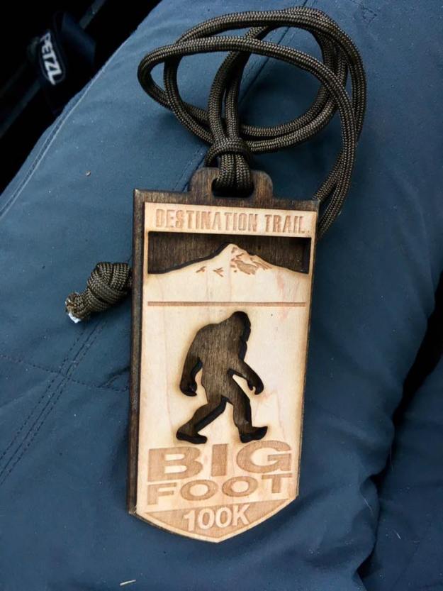
It’s been almost a week after I crossed the finish line of the Bigfoot 100k last Sunday at 8:51am PST. I can’t say that life has gone back to normal, business as usual, back on the grind anymore. I felt that way after my first marathon, ultra, and 50m. Something about the experience out around Mt. St. Helens is different, was different, was unique.

I talk all the time about how anyone can finish an ultra and I really believe that. I like to think I’ve proven that as well, convincing many of my friends to try their hands at a 50k or 50 mile race. Of course, not all ultras are created equal. There are tame loop courses on mild trails, technical trails, groomed trails. There are safe courses where you can’t get lost. There are races that have some rolling hills or some short steep sections, but are overall flat. There are races that are well supported with plenty of aid throughout the race. There are races where any bad weather can only slow you down so much, or put you in minimal danger.

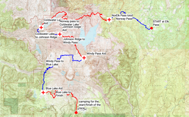
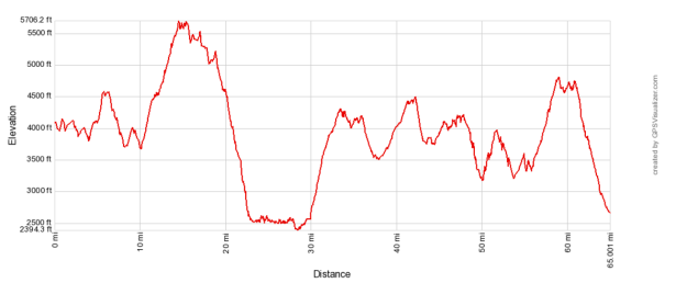
Then there are races like Bigfoot, races that are not for the faint of heart. This race, advertised as a 100k, but truly closer to 110k (68.8 official miles), is a point-to-point trail race on 99% singletrack around Mt. St. Helens. The race involves nearly 15,000ft of elevation gain and nearly 16,000ft of descent. There are only 5 aid stations, on average 13 miles apart. The longest leg of the 100k is 17 miles straight. Most of the race is exposed to the element on mountains trails. There is little cover to hide.

course.png

elevation.png

While the Bigfoot 200 is known for being one of the only non-repetitive 200-mile ultras in the nation, the race director, Candice Burt, started having 2 “short” versions last year in 2015– a 120 miler and a 100k. Last year, the 100k race had only 13 finishers and most DNF’d due to intense storms and downright dangerous conditions. As a result, this year there was a mandatory gear list to make sure you were safe. This list included:

  1. Map with entire course on it.
  2. Headlamp with extra batteries.
  3. Fully waterproof rain jacket.
  4. Wool or microfiber long sleeve shirt.
  5. Lightweight synthetic down jacket.
  6. Water purification method.
  7. Extra calories.
  8. Some form of pants.
  9. Hat and gloves
  10. All clothing items that are not waterproof must be in ziplock bags.

Gear.jpg

What are the chances that the weather could be bad 2 years in a row? Right?

Why sign up

In December of 2015, my trailmate and best friend Ryan sent me a link to Bigfoot. I read the description, I looked at the beautiful sunny photos on ultrasignup.com of Spirit Lake and Mt. St. Helens, and within 5 minutes I decided I was going to sign up when registration opened. The race wasn’t for nearly another year; I had all summer to prepare myself. I wanted to challenge myself and find a reason to explore the PNW. This race was perfect.

I signed up Jan. 1 when it opened and whimsically put the link on my facebook page, almost daring anyone to sign up with me. When you are friends with as many weirdos as I am, there’s sure to be one other daredevil in the mix who is susceptible to whim. That lucky friend this time around was Heather! She told me she signed up, too and since she was coming back from a long running hiatus following her Rocky Raccoon 100 mile finish, she kept this sign up on the DL. Awesome! I was immediately stoked that I would know at least 1 other person going to share the adventure.

While I’ve done a number of other races in 2016—this was always my goal race. Everything I did was in prep to conquer this race. With that in mind, let me talk about how my summer adequately prepared me for MOST of what I encountered at the Bigfoot 100k.

  1. Pinelands 50m—prepared me with distance. As only my second 50 mile distance, the Memorial Day Pinelands 50 was a good test for distance for me. While the race itself was boring, I would need to be able to move the distance. This race was the start to a number of summer adventures that helped me.
  1. Rainy/cold Vermont weekend. We may have only done 22 miles over 2 days, but it was windy and rainy and cold. That type of weather was a shadow of what Bigfoot was, but it’s always good to get experience around 4000ft. up in those elements.
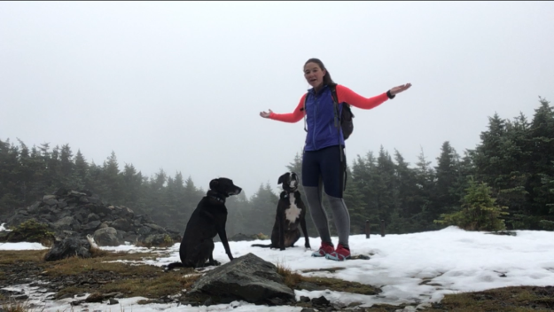
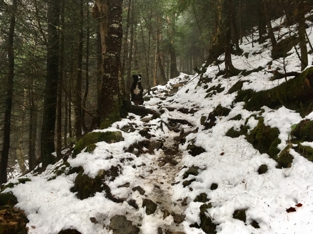
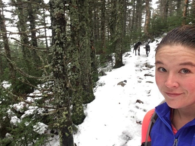
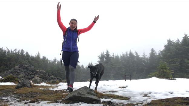
  1. Big weekends in the White Mountains. There are 2 specifically that I am thinking of. These mountains are hard, unforgiving, and don’t know the definition of the word “switchback”. Weekend 1 was 3 days: Mt. Washington Road Race, Zealand Mountain, and then Kinsmans & Cannon. Weekend 2 was also 3 days: Tripyramids, Hancocks, and Presidential Traverse. Time above treeline in the whites, especially during the Presi were helpful because the ‘boulder field’ on Mt. St. Helens was nothing more than what my beloved rockpile Mt. Washington trails are like! Both weekends were filled with lots of elevation gain and descent practice, lots of time on my feet, and lots of time with Ryan! (Okay time with Ryan wasn’t exactly prep, but it made prep more fun.)
  1. Pacing Lauren during the Vermont 100. Oh man, we thought that night was bad? It was great prep for what I encountered in Bigfoot. I joined Lauren for 30 miles, from 11:00pm-8:30am through 3 MASSIVE thunderstorms. That was great experience running overnight and through the rain. I didn’t know it at the time, but it was exactly the experience I would need at Bigfoot.
  2. The Pemi Loop(s). The Pemi Loop is considered one of the ultimate tests in the White Mountains. I already wrote about the first time I finished it. What I didn’t write about was that I did it AGAIN about a month later with Dani (and Cayenne). The second time, we added another mile and another mountain- West Bond (#43). This gave me great time on my feet, distance, and elevation change training. Plus, those trails are far more rugged and steep than anything I’d encounter in Bigfoot.
  1. My August of cross training. I didn’t write about this but after my first Pemi loop (and with the culmination of my July activities), I ended up with 2 small tears in both my calf muscles in my left leg. I’ll get to how I fixed that later, but in the meantime, I took 4 full weeks off from running and I didn’t let that ruin my training. I worked on my balance, training the small muscles in my feet. I swam a bit, nothing less than a mile at a time. Most importantly, I put in a lot of hours on my Trek road bike both in Boston and during some time in NJ. I biked 30-40 mile rides regularly and was able to find some hills. I probably would not have cross trained as effectively if I could run/hike during this time so perhaps it was a blessing.

So how did all of these things help me? Efficiently and effectively. Almost all the elements were present in my training that I would need during my race (except for some pretty unique challenges).

Race weekend

So Heather decided to try her luck at the 120 mile distance, which meant that her race started Friday, almost 15 hours before my race. We met up Thursday in Portland, OR and I broke my 3-week sober pre-race streak with a delicious Oktoberfest, Blonde, and Hazelnut Porter from Alameda Brewing near our hotel. We both went to sleep early and slept nearly 12 hours, which was great. When we woke up Friday, we grabbed coffee, breakfast, and then were off to Marble Mountain Sno-Park to check in and get Heather on her way. It was a beautiful drive and after checking in, we drove around some to try to find Mt. St. Helens.

Well we found it.

Heather and I.jpg

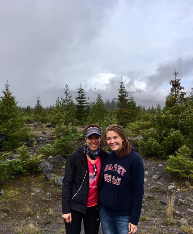
I yelled and nearly crashed the car when I saw it appear. What a sight! It was one of the few sights of the mountain that I’d get that whole weekend unfortunately.

After we had the pre-race meeting, I got Heather mentally ready and sent her onto her bus, which would drive her to the start of her race. I drove back an hour out to the nearest town to get some sleep.

Heather_Bus.jpg

Race Day

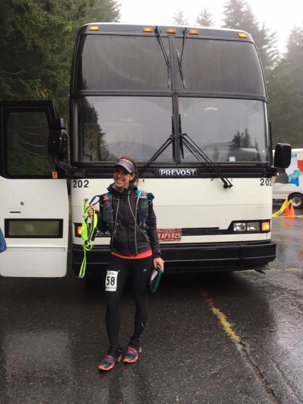
I had no trouble whatsoever waking up and getting myself to the car. I was so excited, so ready to start. I wasn’t even nervous. I just knew that I was going to enjoy this and that I was ready.

Well, no matter how ready I was, I couldn’t start until we got to the starting line. All the 100k racers hopped on school busses for a 90 min drive to the official start at Elks Pass. I was on the third bus. After ~60min of driving, we hear over the radio “Hey I think we’re lost.” Turns out the busses missed a turn in the fog and were stuck on a narrow logging road going up a steep hill. 45 minutes later, the busses each had to navigate a tight 3 point turn. Our bus driver was beside herself, announcing how she hasn’t been doing this long and was nervous which naturally made me scared. During the turn, the bus was tilted back, going uphill and it stalled while trying to drive forward for a second. I was never more awake than I was in that minute.

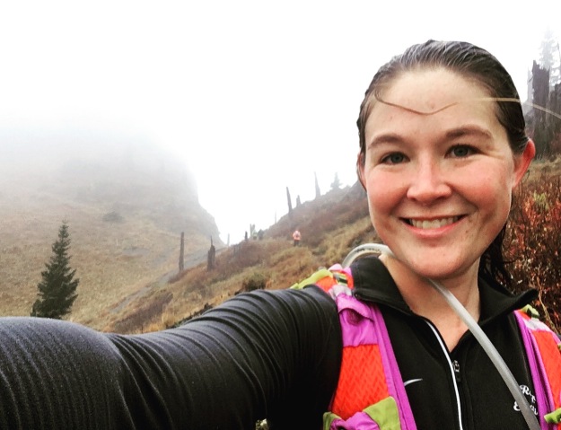
Eventually we made it to the start a bit late. There would be a 45 min delay in start, pushing the official start back to 7:45am. Before we started, I had to pee. I ran off behind some trees and some other racers had the same idea. While crouching to pee among some foggy tall pines, I put my hand down in the soil for balance. After I had my stream going, I felt something wrap around my fingers and along my hand. I am practically gagging just remembering this… I looked down and saw a HUGE earthworm giving me a good luck hug. I immediately started gagging and threw up my banana and granola bar breakfast. I was also still peeing and trying to get the worm off. The result was hilarious: I peed on my leg/shoe, threw up on my shorts, lost my precious calories from breakfast, and fell over hopefully missing most of the carnage. Maybe 3 people saw me and asked if I were okay, to which the answer was obviously NO but I said I was and prepped myself to start. It was such an eventful pre-race!

Elks Pass to Norway- 10 miles. +2288’/-2691’

Most of this section was really enjoyable. The trails are nothing like the east coast trails! I barely saw a root or rock and there was nothing to trip over or roll an ankle on! There were plenty of puddles but the weather wasn’t so bad to start. It was foggy and drizzly here and there. If this weather held, I would be in heaven!– spoilers: the weather doesn’t hold.

The major event of this leg was around mile 4, when I was wedged in a group of men running and at the same time 3 out of the 7 of us yelled! Someone must have disrupted a wasp nest on the ground and they were out for runner revenge. I was stung on my calf. I have never been stung by a wasp before and that sucker hurt. It made me run fast to get out of there. I can’t believe there were wasps that high up! I learned later that they were stinging everyone who passed for hours.

This section was beautiful, with tall coniferous trees and views of the mountains we would climb next. It was a great warm up. I ran some of this section with various groups, but importantly, this was where I first met Dan—a PNW local who I would end up spending most of the race with.

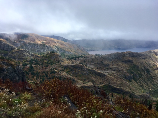
Norway to Coldwater Lake- 17 miles. +3682’/-4834’

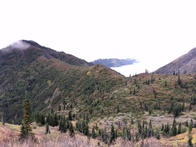
This section starts with a long, long climb up Mt. Margaret that provided wonderful views of Spirit Lake. After a long climb over the pass, you descend forever down to run along Coldwater lake into the aid station. The weather was still pretty great for most of this leg; I even stripped down to just my Janji singlet for some of this section.

Dan and Jason.jpg

This section was breathtaking and also mostly runnable. I hiked the big climb for the most part. I did not want to run out of energy, not knowing how I would fair once I entered new distance territory. During this section, I met Dan’s friends Jason and Kerstin. I would spend a large amount of time running with them as well!
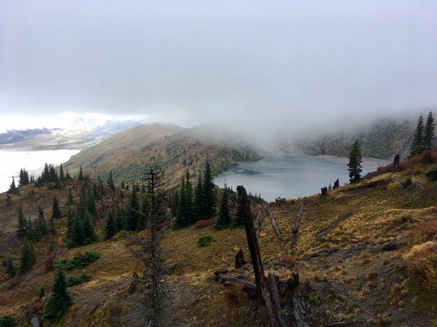
N to CW 3.jpg

N to CW 4.jpg

Spirit Lake


The calf was swelling and red and oozy from my wasp sting. When I got into the aid station at Coldwater Lake, I wasn’t sure what was going on. I told some of the volunteers or crew for other runner what had happened and one person asked me if I was allergic to stings and if I had an epipen. I found this hilarious and just started laughing, which probably came off as rude. My dream of using an epipen mid race almost came true! Alas, I took a Benedryl instead and while that reduced my allergic reaction, it made me super tired. Oh well, no time like the present to fight drugged fire with drugged fire—I chugged some coffee. I felt good, I felt ready to continue. I was only 30 miles in.

Norway to CW.jpg

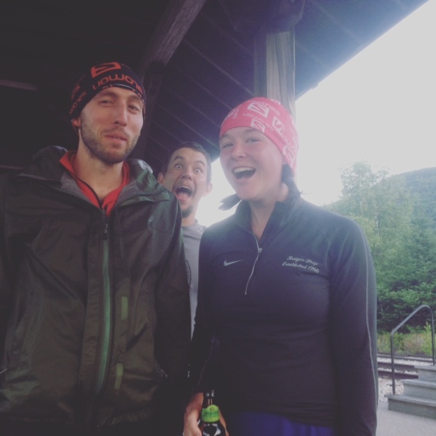
Jason and Dan up in front of Kerstin

N to CW2.jpg

I cannot get over this photo.

NW to CW .JPG

NW to CW selfie.JPG

Genuine smile, I LOVED this course

Norway to Coldwater 2.jpg

Janji Singlet.jpg

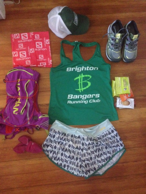
Janji singlet makes a brief appearance! Runjanji.com

At this Aid Station, I refilled water, ate half a veggie burger, and from my drop bag I switched my buff. Out I went for the next short section climb!

Coldwater Lake to Johnston Ridge- 6.6 miles. +2287’/-612’


Mt St Helens.jpg

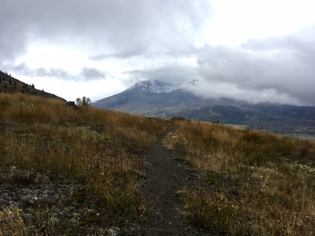
The only view of Mt. St. Helens until we were on her!

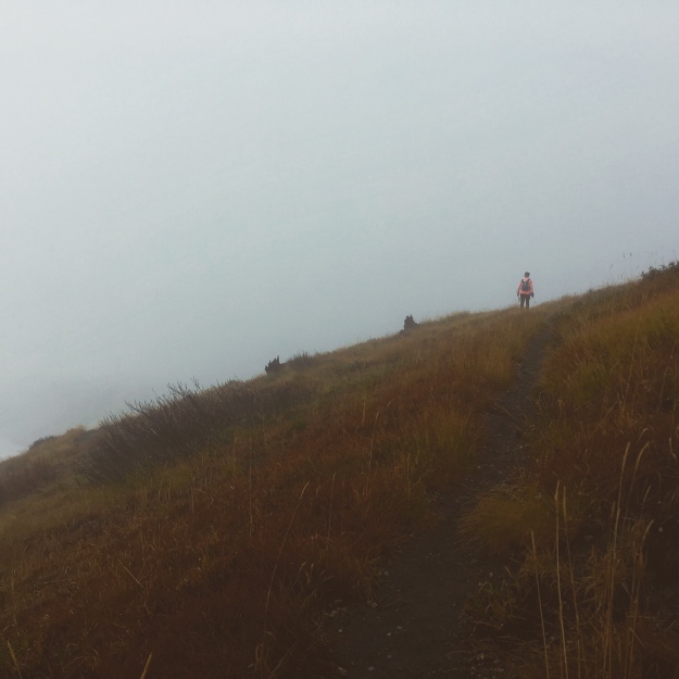
This section was mostly a hike for me. I spent much of it alone, just trying to take in the view. We climbed up a large, cliffy pass that had a breathtaking open view of Mt. St. Helens and I couldn’t stop grinning ear to ear. I was so happy to be in this amazing place, in the rain even, just enjoying the challenge.

I got to the top with another woman named Kelly whom I was chatting with a bit. She worked in child research in Seattle as well—studying a slightly different domain. Such a small world!

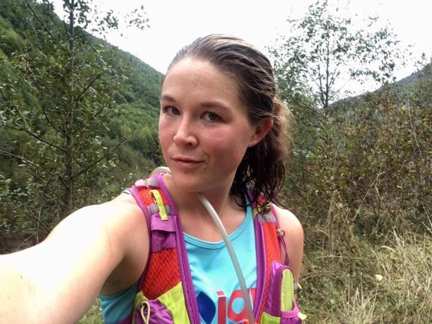
At this aid station, I sat near the heater for a bit. I was 36 miles completed, just over halfway. The easy half was done, the hard stuff was coming. It was windy and getting cold. It was raining a bit, but nothing too serious. I was still carrying all my gear and wearing only shorts. I wasn’t cold… yet. I had some soda and a grilled cheese and some soup. Then I was out.

My only heat source.jpg

My only heat source for a while, and my last photo of the race

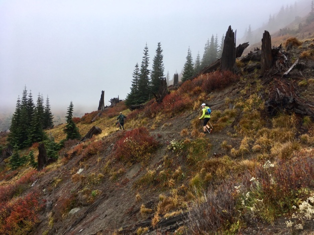
Johnston Ridge to Windy Pass- 6.7 miles. +1189’/-1244’

It was cold and rainy and getting dark. My iPhone doesn’t have a case so I put it in 2 ziplocks and shoved it deep in my pack. It would not come out for the remainder of the race.

It was starting to get dark. Headlamps came out and this is when much of our group solidified. I met another runner named Kevin from Idaho, Jason and Dan, and myself were to spend most of the rest of the race together. Together we hiked and chatted for most of this section, getting to know our stories and experiences and sharing what knowledge (or lack thereof) we had about the race. The time seemed to fly by with them by my side! We heard elk in the distance, caught headlamps maneuvering on ridge lines far away, and started to settle into a slower moving rhythm.

Windy pass aid station was a saint in the night. It was a couple of tents and there were a bunch of runners there when we arrived. Upon our arrival, the rain began to fall. I mean it started RAINING. It was raining a little for the first half of the race, but now it would downpour and continue to do so until well after I finish the race many, many hours later.

At this point, I could feel blisters forming on my heels. I had someone put some moleskin on it, but with the rain, I wasn’t confident that they would last. Oh well—nothing much I could do. I took some Advil and talked my team into heading back out into the rain.

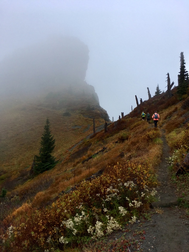
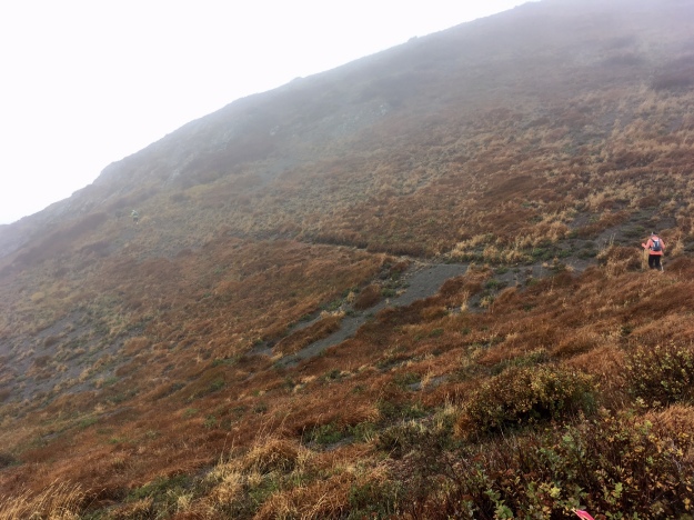
Windy Pass to Blue Lake- 14 miles. +2818’/-3732

Okay. I was feeling really, really good at the start of this section. I was encouraged! Only a marathon left to go! There would be no views, no reason to stop. I had energy and felt like I could move faster than the group. I considered splitting and trying my luck on my own, but am glad I changed my mind to stay with people. This section ended up being incredibly dangerous and slow.

This section runs alongside and around Mt. St. Helens in the blast zone. There were no trees, very little scrub, and just ash. Slippery, ashy trails. There were lots of water crossings now as well, lava made streams carved into the mountain.

The trails were narrow, singletrack. If you slipped on one end you could fall and without trees or rocks to grab, you could really fall. At one point I slipped and at another Dan slipped. We both caught ourselves, but then we directed our headlamps down into the abyss only to see just that. We would’ve been pretty much screwed. I slowed down, I couldn’t run, paralyzed with fear.

It was during this stretch that the fun ended. I put on my rain jacket and my hiking pants over my shorts. I remember being ~ 5 miles into this section and thinking this exact thought: “Hey. I don’t want to play anymore. I am freezing. My gloves are soaked. My shoes and pants are soaked. I’m tired. I don’t want to play for another 8 hours. I’ll just stop.”

This thought was so profound to me at the moment. This wasn’t your dad’s first road marathon. This was a rugged, remote, dangerous, survive it trail ultramarathon. You can’t just stop and have a volunteer save you. You are on your own. Survival kicked in, I stopped thinking any thoughts at all and just marched. This section was long, but I kept marching.

I didn’t even think twice about water crossings, even the Toutle river. I just waded through—it didn’t matter, I was already soaked. There were 3 rope sections, where the trail was steep enough to require a rope. The first was a descent and I’ll give it to the trail—the rope was helpful. The next 2 rope sections were ascending after the river crossing and this was the section where I started to get my good attitude back. I saw the “Steep: need rope” section and laughed. This was NOTHING compared to what our White Mountain trails were like! I easily hopped up this 100 ft climb hand-over-hand while others waited in line to use the rope. East coast trails are not trivial, they are rougher and more rugged than most of this course (until the boulder field). We then climbed and descended for another hour or so until we came FINALLY into the Blue Lake aid station, a place I was starting to doubt even existed.

At Blue Lake, I was feeling hypothermic pretty bad. I was completely soaked. I got out all my layers, changed my base shirt and buff, batteries in my headlamp, and put on my down jacket under my rain jacket. I hung out near the lamp trying to dry my pants, but really, what was the point? It was still pouring outside. I didn’t even bother changing my socks because they would not stay dry over a minute. I hung out here and ate some more soup, re-stocked my gels and rested for a very long time. Kevin told me that this was his first 100k and longest run ever also. He seemed happy to have made it the 57 miles already and was unsure how the last bit would go. I told him we were going to make it. Dan left a bit before us with a pacer. Jason picked up a pacer named Angela who ended up guiding our group out. I am forever grateful to have someone cheerful to guide us and making sure we were making all the right turns. One more leg and then it’s over!

Blue Lake to Finish at Marble Mountain- 12 miles. +2614’/-3172’

This section starts with a long climb up into the boulder field, then you navigate across the boulder field, and then make the final descent.

The climb was brutal. My blisters on my heels were agonizing. At least I was able to warm up some while climbing. I kept my head down and tried to stay with Angela. She helped keep us moving at a great pace. We were over to pass a few people and get to the boulder field in good time.

The boulder field was nearly identical to what the Presidential Traverse above treeline looks like. I was VERY familiar with those types of trails and felt right at home, while almost everyone else was in a panic. The difficulty in this section was navigating the trail. There were no cairns and we were reliant on the sparsely used reflective race markers. We went off course a few times and Angela, bless her soul, offered to do most of the dirty work in finding the correct way. Once we found it, we were able to navigate through most of it. Then the sun started to rise. It was still pouring but the sun was coming up. We would live!

Or maybe not. The boulder field was very exposed and windy and we were done climbing and doing a lot of slow moving or standing. This did not help my hypothermia. I was getting very cold, and my hands were quite numb. I tried to keep them in my pockets as much as possible but the boulder field often required hand support. After we made it through most of the boulders, the others were much slower moving through it. I made an executive decision at that point that I could find the trail on my own at this point and would need to run in order to stay alive. I needed to get warmer and running was the best way.

The sun was up, the rain was still pouring, I had 4 more downhill miles to go. I had plenty of energy left, my muscles felt surprisingly fine. My only bodily pain was blisters on my heels. I ran those last 4 miles fast. Passing a few people on my way out!

I finished in an official 25:06:52. 41st finisher. I immediately saw Heather, who did not have her ideal race, but I was glad to see her feeling better.

Post Race

Finisher Award.jpg

So I did it. I finished my goal race and all the associated challenges of that particular race. I met some incredible people, some inspiring 120 milers, and saw some terrain that left me breathless. I did the first 50 miles in 15 hours, and the last dark 19 miles in 10. Could I have finished faster? Yes. I didn’t leave it all out there, and that’s fine! I wanted to finish alive, and now I am even hungrier to perform better, to run more!

It’s not nearly a week after my race and my body feeling both awesome and awful. My muscles and blisters are fine! I use healing Band-Aids on my blisters and they are good to go in 2 days. My legs felt fine, I sustained no injuries. My shoulders and back are sore, and that in exacerbated by my cough but I was able to run twice this week. I am suffering from a really awful cold that I’m sure I acquired during that rainy wet cold night. It’s better now, but I was stuck in bed.

I am still buzzing from the experience. I walk around knowing that what I went through isn’t a common experience. Sure.. “everyone can run an ultra” but I would not say that everyone could finish that Bigfoot race. I know that this race has changed me, changed my perspective on what is possible and what I am capable of. I didn’t even seriously think about dropping at any point (other than in the middle of that one section where I couldn’t actually drop, thankfully)! I am hungry for more and know that I am capable of running longer distances and maybe more mountain ultra races. I’ve shattered my glass ceiling this year.

This week I’ve forced myself to never drop from challenges. No giving up because something is hard, or you are stressed, or sick, or tired. Case-in-point, I have a manuscript submission deadline approaching tomorrow that I have been scrambling to throw together a submission. While working with my co-authors on getting it ready, I could easily say “we can miss this deadline and just submit it some other place” which is a perfectly reasonable thing to do. However, yesterday when my advisor came in and asked me “Do you think it’ll be ready to submit Saturday?” I sat quietly, looked around, and said “yes!” because even if it isn’t, I’m sure as shit going to try to get it ready. (It’s not quite ready right now, but I still have all of tomorrow to get it done before the clock runs out! No DNFs.)

People to thank, important people!

First, I HAVE to thank Boston University Physical Therapy, specifically my PT Roni Mielke. She worked with me 2x a week to fix my calf muscle that I tore 8 weeks pre-race. At that point, I thought it was pointless. I would miss prime training time because of this and then would have to build back strength. Roni thought otherwise and she worked me hard and gave me homework that I did diligently. After 3 weeks, I was able to walk around painfree, even on hills! She gave me a green light to try “some easy running and hiking”… which was when I went for my 2nd Pemi Loop (it counts as some hiking, right??) and when I was able to do that pain free, I knew I was in the clear! If you are suffering injury and want to work on it, get a script and go see BUPT.

Ronnie and I.JPG

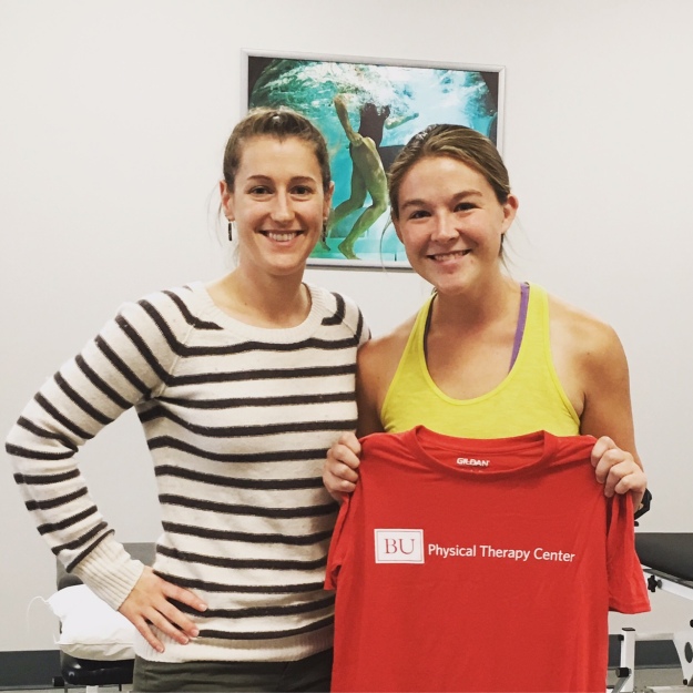
Roni and I with my “graduation” shirt!

And Roni, who is from Washington state, was actually getting married in WA the same day as my race! I briefly joked that if she didn’t fix me before my race, I already had a plane ticket and would just go to her wedding. Perhaps that was a little extra motivation for her to get me back to tip top shape.

Secondly, I want to thank my sports masseuse– Anna (Manna Massage). Anna is a magician with her massages and she’s great to talk to and will try to give you preventative advice. I’ve been going to her for about a year now and I recommend her to my running friends and will plug for her now. Go see her if you’re in Boston, especially near Brighton! She’s right near the Chestnut Hill Res.

Third, I want to thank Ruby and Jenna—my roommates who are not only really tolerant of my freaking out about everything, but also took care of Sky while I was away.

FullSizeRender (30).jpg

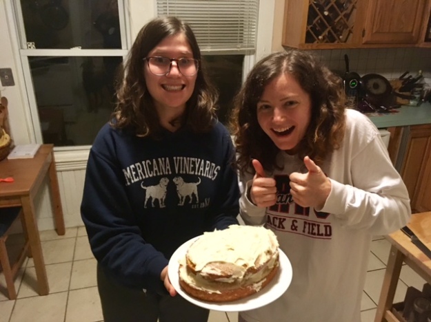
This photo is indicative of my roommates, I think

Last but not least, I really want to thank Heather. Heather and I were never very close when I lived in NJ but that’s not because I didn’t always want to run with her! She is an inspirational runner and person, compassionate in her job (a veterinarian), intellectual and well read leader of our book club, philosophical and hungry to take classes, interested in learning new languages, and she doesn’t give up on anything. Heather went to attempt a freaking 120 mile mountain race in the storm. She had to drop 75 miles in after wandering around with upset stomach and unable to eat or drink for 20 miles. She made the right choice to stop and live another day and while she might not believe that the DNF was okay right away, I hope she will soon. It is no way an indicator of failure, it’s just an indicator that she’s as smart as she looks. I’ll take the lessons I’ve learned from watching Heather tackle races like Manitou’s, Whiteface, and Breakneck Point and try to carry myself with the poise that she has.

Pre race beer.jpg


So here I am, up around 11:30pm on the Friday night following my race. What’s next? I don’t know. I have Ghost Train next weekend and TARCkey Trot in November still this year. But similar to how I aimed high for Bigfoot more than 10 months before race day and how everything I did in 2016 was leading up to it—I think Ghost Train and TARCkey Trot will be prep races. I want something bigger and now that I’ve finished my 100k, I am ready to go for it. I just have to register first, but I’m going to run the Vermont 100 mile endurance race next summer.

EXTRAS: Want to see more cool photos? Photographer Howie Stern did an amazing job shooting the race, with a few shots of me! Check out his page here! His photos tell the real story, and also capture the real rain that we had!  I recommend checking his photos out even for just inspiration!

A different take on the Pemi Loop

I’m not the first, nor the fastest, nor the funniest person to have completed a 30 mile, 18k elevation change, Pemi loop. I don’t want to write up another “first I walked over a bridge, then I went east” etc. douchy report about the hike. If you want to find out details about the hike, you have options! You can:

  1. Google “Pemi Hike” and search away for the many other bloggers or AMC workers who have knowledge about the route and elevation.
  2. Ask me specific questions, I can chat about the experience in person and will probably give a more animated and, dare I say, entertaining description!
  3. I don’t have a three but lists with only 2 items are kind of lame. Either way, I’m sure you can figure out other methods of learning about the Pemi loop.

So, instead of my traditional boring report, I thought I’d do something different this time. I’m going to take slices of my hike, with a timestamp and location, and write to you my internal (and occasional audible) monologue/dialogue that was a running commentary of the whole experience. If you think talking to me is annoying, take pity on me! I talk to myself all the time and can’t get away from me!

So first, I’ll give you the quick and dirty on the trip, so that you have an idea about how far I am and what time it is during different stops on the ever-exciting monologue express (choo choo!)

Friday night I couldn’t sleep. Not totally uncommon, but I typically can’t sleep the night before I am considering a long run or a big hike. Instead of having to wait around until morning like I have to if I’m hiking with others, I decided—hey fuck it! I’ll go hike that sucker now. So at 10pm I drove to Lincoln Woods with my dog and bags in tow and was on the trail at 2am. I also decided on a counter clockwise loop. I chose this route because I have some weird mental block about the Pemi loop going up flume first. I’ll get into more detail about that in a more serious, lame, soul finding bit at the end but for my own mental sanity, I chose CCW this time. I’ve read that the benefit of the CCW loop is that the long flat Lincoln woods trail is done early, which drags on at the end of the hike. The drawback to CCW is that you have a lot of climbing to do late in the day, scaling Lafayette for example at mile 20. It didn’t matter, mentally, CCW was what would keep me going and in the event that I had to bail (or had to help Sky bail), I would at least have seen Bondcliff finally.

Okay so got the details? CCW loop and 2am start. Just my dog and me. All aboard? Let’s start this wild ride.

2:15AM Lincoln Woods Trail, 0:15 into hike

What the hell, Sky? Why are you so slow tonight? Yeah it’s late, yeah it’s dark but you are a dog. You literally just sleep all day. You didn’t have to drive here. Why am I putting such distances between us just by walking. We should be running this section! Sky, c’mon let’s go. She really hates wearing that pack. I don’t get why. She should be more used to it by now. How can a dog who runs runs runs all the time just crawl right now? Are we even going to make it to Bondcliff? Why is she being such a butt? Maybe it’s too heavy. I know, I’ll just dump out her water and make it lighter. Sky, come here, let me… okay there now you have no water. Wait, I’m an idiot. Why even have the pack on her if she isn’t carrying water? Ugh what if it gets hot early? I should just go back and dump the pack but I don’t want to add more miles to this already. I’m so stupid. I just won’t drink any of my water and that way if she needs it, then she can have mine. Wait that is stupid, too.

3:00AM Lincoln Woods Trail 1:00 into hike

Oh my god oh my god oh my god I’m going to die here. I swear to god I am going to die here. There are monsters and bears and moose and all kinds of bad shit out there and I’m just alone walking into it. Fuck fuck fuck what was that sound? Sky, stay on the path please. I am such an idiot, why did I watch a scary movie today? Why why why why would I do that? Trails at night weren’t so scary before, ugh I am going to die here—–WHAT WAS THAT? OH my god please Sky can you just try to run a little with me please. I’m going to just start yelling, make sure all the bear and moose know I’m here… HELLLO BEARS I HAVE A DOG. I’ll just yell that every couple of minutes… oh shit. Oh shit oh shit what is that? Something written with sticks on the ground and an arrow? What does it say? “Help me”? ARE YOU FUCKING KIDDING? There’s a goddamn arrow pointing down the trail I have to take? Does it say “help me”? I’m not going to look again, jesus I don’t want to know. Oh my god this was such a stupid idea. [This really happened]

3:30AM Lincoln Woods Trail 1:30 into hike

GOOD GIRL SKY. I’m going to just keep yelling that every 3 minutes. I haven’t seen a bear or moose or anything bad yet. Good thing the scary movie I watched was just The Exorcist and not the Blair Witch Project or something… fuck now I’m thinking about the Blair Witch Project. Fuck fuck shit I’m so dumb. Sky, stop trying to eat toads. As soon as you catch them, they just pee in your mouth…

4:30AM BONDCLIFF SUMMIT 2:30 into hike

Holy shit, this is the most beautiful moment of my life. I just experienced more stars than I’ve ever seen before and now this sunrise. I’m alone, there’s a strong wind waking me up, and the summits of mountains are all around me, 360 degrees, rising out of the undercast clouds like the heads of titans. Look! There’s Carrigain, Franconia ridge, Willey, Field, wow this is.. wow. Flashlight off, let me just sit, I think I might cry.

6:45AM somewhere near South Twin, 4:45 into hike

The sun is really up now. I can’t believe what a morning that was. I still haven’t seen anyone, this is really perfect. I wish Sky would move faster though, this is so runnable.

8:00AM Galehead Hut 6:00 into hike

Breakfast for the backpackers, the hut is packed! No dogs in the hut, I’ll have her sit outside while I go in and refill her water bottles that I stupidly emptied and refill my own water. Hmm… I guess I didn’t drink much? I barely have to refill. I really am just so stupid, why didn’t I drink more? Oh well. I’ll feed Sky, too. I could shoot up Galehead and back. It’s a mile round trip and I already missed the West Bond spur. I’m not sure how Sky will fare now that it will be warmer, not sure how I will feel either. I’ll skip it. I’ll be back attempting more Pemi’s in the future anyway.

9:30AM Trying to get up Garfield 7:30 into hike

Man, fuck Garfield, fuck this climb, fuck this waterfall. Holy crap this asshole mountain just shoots out of the ground out of no where and then I have to go all the way back down? This is so stupid. Who is Garfield anyway? Not cool enough to be in the Presidential range, huh? Isn’t Garfield a fat cartoon cat? Fuck this fat cat. Sky is mostly a mountain goat, but I’m doing a lot of helping her on this climb. It’s not even such a huge climb, maybe 1000ft but sharp, so sharp. Ugh, just keep pushing.

10:15AM Garfield Summit, 8:15 into hike

This is my first summit with people! Real people to talk to! I met some dude who was running the loop CW (smart, lucky man) and some day hikers as well as 2 dudes and a dog who slept on top of Garfield. It’s nice to finally be able to talk some. Worth the rest and time for snacks also. I know what is coming next, long descent and then the last big climb. I’ll let Sky rest some more, I think she’s already asleep… “Hey thanks! I love Janji, great company and they make my favorite shorts.”

11:15AM en route up Lafayette, 3.7 miles from Garfield summit to Lafeyette summit, 9:15 into hike

Seeing a lot of people now, it’s a decent hour where people are actually awake. It’s getting warm, too. Especially in these little clearings in the sun. Oh look, more runners! Man I wish I were running. “No you got it, come through. You’re still running..” Oh, that guy knows the Brighton Bangers! He’s running with a few runners from Community Rowing, I didn’t know they had a run club. Cool.. that one guy with the beard is pretty cute. Small world, I think most people doing the loop that I have talked to are from the greater Boston area.

11:50AM very close to Lafeyette summit, 9:50 into hike

LISA?? Oh my god, what a place to run into you. Oh, you think I look fresh? Thanks! Just the pick me up I needed. Enjoy your pemi loop!

12:00PM Lafeyette summit, 10:00 into hike

holy fucking hell, how did all these people get here already? Oh my god, there must be 150 people on this summit, at least 9 other dogs. Oh my god this is going to be awful. I didn’t think Franconia Ridge would be this packed. No, don’t let your dog just run over to mine. No sorry my dog’s water is not for your dog. Fuck off everyone go away. Sky, sorry we can’t rest here, I’m so uncomfortable.

A running monologue for the Franconia Ridge section from Lafayette to Lincoln

Okay, okay, let’s go. Sky, c’mon please lets try to run the 10 yard sections between groups of hikers that we can? I want this stretch to end as soon as possible. Ugh, “ha ha ha yes her backpack is cute”; “no she is tired and doesn’t want to play”; “no I don’t make her carry my things, she carries her own food and water.” Sure you guys take your time, you and your 25 person group can slowly go up this 7 ft rock and not give me 2 seconds to literally jump down. “no I don’t make her carry my things, she carries her own food and water.” Oh my fucking god just move over. Sky, keep up… “no I don’t make her carry my things, she carries her own food and water.” What a tale of 2 halves of the day. I couldn’t have been happier at 4am alone on the other side. There must be close to 1000 people up here. This is worse than the mass pike on a Friday afternoon. “NO I don’t make her carry my things, she carries her own food and water.” I hope to god it gets better after Lincoln. SKY COME ON. This is the slowest final 8 miles of anything I’ve ever done. “No she doesn’t want to play with your dog she’s tired” oh your dog is tired too? Can’t tell by how it’s pulling you all over the place, did you put 25 miles on your dog already? Oh for fucks sake “no I don’t make her carry my things, she carries her own food and water.”

[I realize what a snob I am inside my head but rest assured, I was nothing but polite aloud to anyone. However, I will NEVER attempt to be on that ridge on a good weekend day in the summer every again.]

1:00PM Just past Lincoln, 11:00 into hike

Finally, oh my god finally. Still a bunch of people on this side but in comparison, it’s deserted. I am low on water and Sky is out. We just have to perservere at this point. Liberty is kind of an annoying climb this far into the day and Flume after. At least we will have less people and nearly no reason to hang out on the summits. We’ve been on Flume and Liberty maybe 6 times already.

2:30PM Franconia Ridge after Liberty, 12:30 into hike

I’m on autopilot, just ran out of water, still tons of people slowly going up liberty or going down. I can’t believe how much time we’ve wasted on this ridge.

3:00PM Just passed Flume, 13:00 into hike

FINALLY, 5.5 miles until the bottom, I am tired but I know this is the gently downhill we need. I’ll walk some and run some but we are MOVING. Sky, there will be water at the bottom, at the glorious bottom. We are not so far away. Let’s go let’s go let’s go.

5:00PM Dunking myself in the Pemi River by the trailhead, 15:00 & finished

Oh my god. So this is what it feels like to finish the Pemi loop, huh? I feel awful. I am tired. A girl on a bike just yelled at me because Sky walked in her path. “Leash your dog!” yeah… I get that she doesn’t want to get hurt or hurt my dog but I am way too tired to care. The hike alone is tiring, but without sleep for 36 hrs at this point, plus a drive back to Boston, I can’t be bothered with people. Her stopping her bike shouldn’t ruin her day completely. I thought I’d feel more accomplished or something but the last 6 miles were really killing me. Like KILLING ME. My feet hurt so much from walking, running would’ve been better. I have to think about how to carry some water for Sky if I choose to run it next time.. I can’t go her “pack pace” anymore. Oh well. Ice cold water on the legs is a relief. I’m going to eat a burger and then go home. I wonder what happened to whoever wrote “help me” back there?

…and we will never know.


Ladies and Gentlemen: that is my Pemi report. I am tired again just from reliving the whole thing. I’m very proud of Sky for now being able to hold the title we all knew she deserved—that of Ultra Dog. As for my own mental state upon finishing, well, I’m not too changed. I didn’t expect to be, but I can’t believe how bad the Franconia Ridge made me feel about the rest of the experience. I shouldn’t let a shared beauty in NH get me down, those hikers have as much a right to be there as I do, and I should have foreseen a busy ridge midday on a clear and beautiful Saturday. I just love when I am in solitude, I like going my own way at my own pace and I like having just my dog around for company. I’ll take that last 10 miles to the bank and learn a lesson for next time.

As for finally completing the loop after failing twice before, I certainly feel glad, but I don’t feel changed. I think that’s appropriate. I (perhaps) jokingly described the Pemi Loop as my “ex boyfriend” of hikes because it was grand, impressive, and no matter how much I knew I was good enough and deserving, it never let me feel that way. Well, here I am proving to be good enough, and still wanting more. Much like my ex.. the first half of the Pemi loop experience was life changing and incredible but by the last stretch, I just wanted that shit to be over.

I took on a few new peaks in the process of this hike: Bondcliff (39), Bond (40), South Twin (41), & Garfield (42). I have 6 remaining peaks– West Bond, Galehead, North Twin (all within an arms reach from the Pemi loop), Cabot, Hale, and the gnarly Owl’s Head (in the center of the Pemi loop).

I try to learn a thing or two from every experience so here it is broken down:

  • Figure out how to make Sky run faster or carry her shit for her
  • Don’t watch scary movies before going alone in the woods… but perhaps watch scary movies before night trail races because I was ready to SPRINT up Bondcliff
  • Drink more water early, chronically failing at that
  • Be patient with strangers, you are the face of trail running and ultra running/hiking to some people so don’t be a dick even if you are tired and cranky and hungry and thirsty
  • Have confidence, you know what you are capable of.

Ahh you’ve made it this far in the post? I’ll reward you with photos.

IMG_8845.JPG

My uniform, plus a black Nike longsleeves

My sunrise photos from the East side of the loop

IMG_8909.JPG

FullSizeRender (3).jpg

The dunk in the Pemi to conclude the day

Beers Before Headlamps: Pups & Patriots Weekend

Last year, Updog (Ryan) and TFC (Ben) along with their friend Alec celebrated our nations great independence by hiking a Presidential Traverse. Simply full of jealousy for a whole year, I tagged along this year for a weekend in New Hampshire with Ryan and many new friends—including Ben, Dani, Mike, Yitzy, Nate, Matt, and Erik.


*disclaimer, most (but not all) the photos in this post come from Dani or Mike, who are more skillful at hiking and documenting and have a better camera on their phones than I.

Friday- Day 1

IMG_8607.JPG

Sky girl is dressed and ready!

I packed Friday morning and headed up to meet Ryan and Dani who arrived Thursday. We had an easy Friday, hiking a flat mile out to Church’s pond for a dip between the mountains and then back. We grabbed food and headed to camp. We started drinking and playing stump and enjoying ourselves. This is where Bad Event 1 occurred… somewhere during this time. Somehow, I lost my “wallet” – you know, that money and credit card bundle that I keep a hairtie around. Unaware of this, I partied on, greeted Mike and Yitzy at their arrival and slept soundly.

Saturday- Day 2

We had a kind of late start on Saturday. The plan was to grab breakfast, and then climb the Tripyramids. This hike includes 3 summits, 2 of which are on the list (#35, 36). After realizing that Ryan was kidnapping us, and taking us to some breakfast joint that was not Bart’s, I realized I forgot my wallet (believing it to be at camp somewhere). Who wants to pay for me? Thanks guys.

The preferred route is up the North Tripyramid Slide, over the peaks, and then down the south slide. The north slide is brutally steep and many sections are loose scree rock that doesn’t make for strong footing. We walked in through the Livermore Pass starting at the Kanc. Round trip was close to 15 miles, slow day on that slide—6 hrs. I will share that I LOVED the slide trail! Gradual uphill & switchbacks might be easier and faster, but the sheer vertical climb, uneven footing, and mental route planning that goes into a rock slide trail is way more fun and, for me at least, that energy translate into speed! Huge credit to our 4 Trail Dogs: Sky, Cayenne, Tuckerman, and Piper 1 who were also champions at this trail where dogs are not recommended.

Taking small breaks on the slide, Ryan and I were able to look out into the mountains, into the Pemi and could, between the 2 of us, identify each and every mountain. I always feel at home in the Whites but I must say that felt even moreso like home.

At night, we again grilled and hung out. Nate (& Perdy) and Erik (& Piper 2) arrived. Bad Event 2 occurred. With so many large dogs (our 6 plus 2 others at camp), dog tensions were running high. I was trying to give Sky a piece of chicken when Perdy just walked by. Sky snapped at her and my hand was caught in the crossfires. Got a nice bite, cleaned the wound and life goes on.

13606492_901061468581_1827271169000678066_n.jpg

Tuckered out little pups

Sunday- Day 3: to hike or not to hike

So with full knowledge that Monday’s traverse would be an effort, Ryan didn’t give a F and planned a Hancocks hike. Erik and Nate arrived the night before and wanted to get onto trails. Yitzy and Mike opted out, for a lazy day on the river (smart boys!). My thoughts were to meet up with all the people I knew who raced the Loon Mountain Race nearby in Lincoln and go to a lake and drink beers all day. However, after not hearing from anyone and being easily persuaded, I joined Dani, Ryan, Erik, and Nate on a Hancocks hike. This was about 10 miles of a lollipop loop, including 2 more peaks from my list (#37, 38).

Doing this hike alone, I would’ve probably ran much of the initial climb into the mountains. The trail was soft and bouncy, filled with pine needle and not covered in rocks so much. The loop part involved one steepish climb, ~1000 ft to a nice view atop North Peak. Then a ridge line trail that slowly ascended the South Peak.  On this hike, we had 5 humans and 6 dogs. We were a pack and maneuvered well together. All the dogs were great off leash, including the scary road crossing on the kanc, at the hairpin turn.

During the ascent on this hike, my left calf burned. I have been having cramping issues with it for a week or two, probably a combination of dehydration and lack of foam rolling out the buildup. I was slow on the climb and felt dumb for not resting today and worried about how I would fare on the traverse. These mental worries are the worst—I’m worried about failing at something I haven’t even started yet! Not only that, but something that I am looking forward to doing! I shook it off and finished the climb, reminding myself to drink more water. The view at the top was well worth it!

Bad Event 3 (and final Bad Event) occurred. Due to the nature of the holiday, many fireworks were set off from nearby houses and towns. As most dogs are, Sky is terrified of loud sounds. She was shaking and I was afraid she’d run away so I put her in my tent briefly while I got ready to join her. In those 15 minutes alone in my tent, poor baby was so scared she peed on my sleeping bag. It wasn’t a lot and it was totally cleanable. I just felt so scared for her, and bad that I left her alone in their at all. I’m sorry, Sky Girl. Never again!

Monday- Day 4: AMERICA TRAVERSE

Okay. The plan was simple and yet not so simple. We at camp had a meeting to discuss logistics. Mike and Yitzy were going to leave cars at the finish and head straight home (to NY) after finishing. Ben, maniacally, was driving up through the night from VA and would meet us at Applachia at the start. Matt was driving up from Boston at 3am to meet at the start also. That left Ryan, Erik, and myself to figure out car spots.

We learned early on in this trip that the dogs were capable of riding in the truck bed of the pickup without jumping out or being scared. In fact, I think they all enjoyed the freedom back there! So we left my car and Ryan’s (and Mike’s and Yitzy’s cars) at Crawford and we piled into Erik’s truck with dogs in the back and headed to Appalachia. We got a later start than we intended but met Matt and Ben and were on trail by around 6:50am.

13600338_10154927496428056_7606455164846850126_n.jpg

Our fine collection of doggos

Our ascent was via the Valley Way to Watson Path to the summit of Madison. My climb was as I thought it would be, a pain in the calf. I thought my muscle was going to explode. Every step was agony after the first 1500ft of climbing. I slowed down, fell behind, but didn’t stop. I knew that once I hit the top, I would be fine with the climbs from there on out. I kept drinking, too, knowing the Madison Hut would be a refill. I brought s-caps with me also, popped 2 of those just after breaking treeline. I felt the pain persist through to the summit, where we rested and took in our first view. 2:30 total time to the summit, but it flew by. After moving again from there, the s-caps kicked in a bit and my pain went away. Thank goodness! I felt good to climb after that!

We moved steadily but slowly for most of the day. Part of hiking with a large group, including 4 dogs, is that it’s easier to stop. While I wish we were moving as a group a bit faster, as in taking less time to stop, I can’t really complain because the weather was AMAZING above treeline. It was clear and sunny and the view was beautiful. I’ve been up there a bunch of times and I think this was the best weather I’ve seen, other than the Mt. Washington Road Race day.. which I still haven’t posted about.

When we made it atop Washington, ~ halfway done with our day, we spent almost an hour eating and hanging out. Because of our 4 dogs, someone had to stay outside with them at all times. Luckily, they were all so tired they just lied down together and watched other people and dogs wander about. The summit of Washington is like Disney, packed with drivers and train passengers and other dogs and children and our pups paid them absolutely no mind. I even took a nap on the ground with them in the sun, warming myself and enjoying the rest.

During this stop I felt like a tour guide of sorts. I got a lot of questions about hiking with dogs, knowing what the dog need, what do I put in my dog’s pack. I also got a lot of questions about my singlet, a Janji India style. Finally, I got questions about day hikes and speed records and trail running. So many people show such an interest in the mountains and mountain running!

Of the 4 dogs, 2 were equipped with backpacks. Sky Girl and Tuckerman both wore Ruffwear Approach packs. Inside Sky’s, I had 2 L of water in soft collapsible flasks (1 L on either side of her for balance), a collapsible food/water bowl, her leash, and a ziplock bag of food, which she ate on the Washington summit. The pack seems to temper her wild trail animal instincts, she is less likely to run amuck off trail chasing shadows and seems to stay on trail more. I think this is overall the best for long hikes like this where she should conserve some energy.

As for the Janji gear! Everyone should be looking to get running/fitness gear from them. Janji apparel features bright colors and fun patterns that reflect the message that Janji sends out. Each piece purchased provides some source of clean sustainable water for 3rd world countries all over. Available clean water sources is a global issue, imagine you yourself spending a week unsure if you could have access to such clean water! As a girl whose trail name is Sweatshop, I for one would not be able to take on these adventures without knowledge that I can get water in places like the top of Mt. Washington! I highly recommend checking out Janji brand and story and picking up some great gear (I am particularly fond of the shorts)!

After I woke up from my dog summit nap, I went inside and scarfed 2 hot dogs and a slice of pizza. I refilled with water and we continued on. The descent from Washington to the Lake of the Clouds Hut is fun and runnable! We got to the bottom and let the dogs play in the lake for a long time before hitting the hut and then finishing the day. We made great time on Monroe, Franklin, Eisenhower, and Pierce before deciding against adding Jackson and maybe Webster. Sky girl had a rough day on her nails and one was rubbed down to the quick—she was bleeding since Mt. Jefferson so I was cleaning it and observing. The Crawford Path down Pierce and out to Crawford Notch (the finish line) is entirely runnable! I spent most of it running a few minutes and then walking a few. Sky girl had the “get me the F out of here” mentality and bolted ahead with Ben and Matt!

Finished at the car around 12:30 total time, changed and immediately downed a beer. The dogs showed us they were made of strong stuff by chasing squirrels while we waited for the rest of the crew to come out. This was my first N-S presidential traverse and I loved everything about the day.

Matt and I even found we brought the same Pinelands finisher Buff and made hats at the end!

IMG_8684.JPG

Hey Ryan, sneaking in

Gear Used:

  • American Flag Shorts, duh
  • Janji India singlet
  • Nike Dry-fit quarter zip for the summit
  • PrAna hat
  • Nathan Vapor women’s vest, everything fit perfectly
  • Darn Tough Socks
  • Topo Runventure Shoes, also a perfect choice for the weekend
  • Salomon Buff, didn’t need
  • Extra Socks for either feet or as gloves, also didn’t need

Nutrition:

  • Trail Mix
  • Trail Pickles (0 calories, all the salt)
  • S-Caps, took 4 I think
  • Pears, Strawberries, and Blueberries baby food things
  • 2 Hot dogs
  • 1 Slice of Pizza
  • 2 finisher beers

Weekend Summaries:

  • 4 new peaks to my list
  • 11 overall peaks
  • 50 miles hiked
  • 15, 500ft elevation gain

Beer before headlamps. Good training for my upcoming 100k– the Bigfoot 100k!

Kinsmans, Cannonballs, Cannon (again)- 33, 34

Okay. So Monday after this long weekend, Ryan and I stayed to play in the mountains! I needed Kinsmans and he wanted to attach Cannon. We made the day into a traverse. Up Cascade Brook Trail to Lonesome Lake. Then Fishin’ Jimmy Trail up to Kinsman Pond campsite. Then up both Kinsmans and back to the pond, quick refill of the water– then the tiresome Kinsman ridge trail over the cannonballs and steeply up Cannon. Then down Cannon on the otherside after a trip up the tower! All in all, a long weekend of climbing and mountains.

I think I got some good base miles on and am looking forward to getting stronger from this experience. I’m coming for you, Bigfoot 100k!